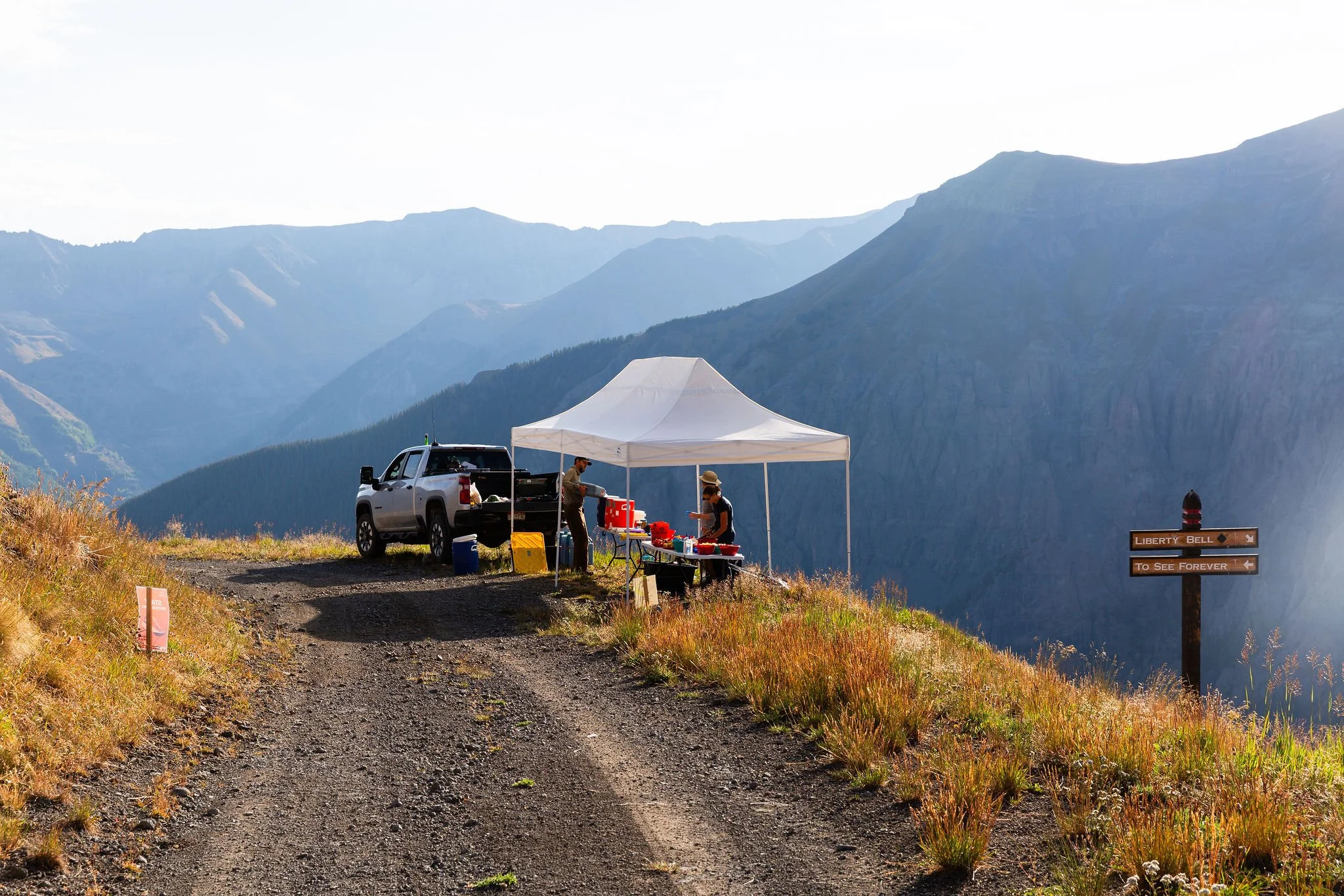
Aid Stations
TMR is a CUPLESS race. please bring your own reusable cup if you plan to drink at the aid stations and finish line.
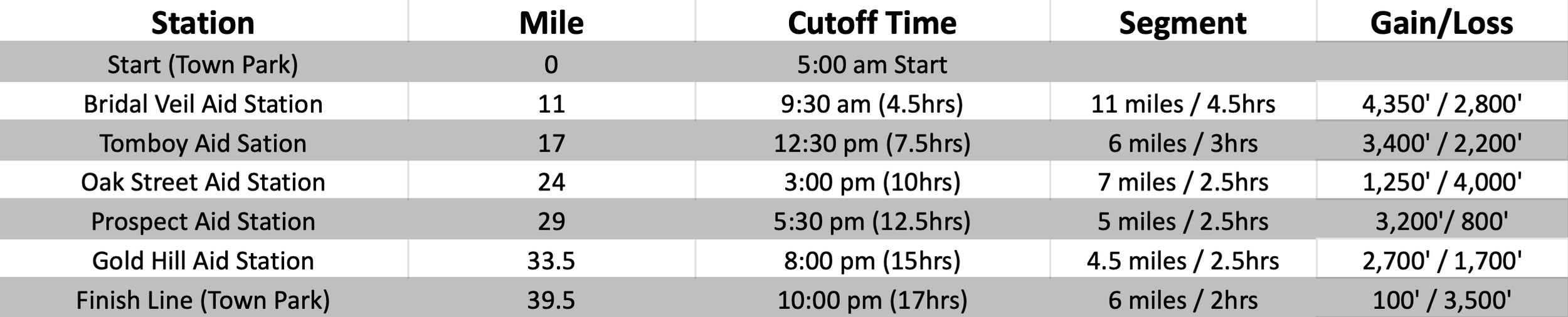
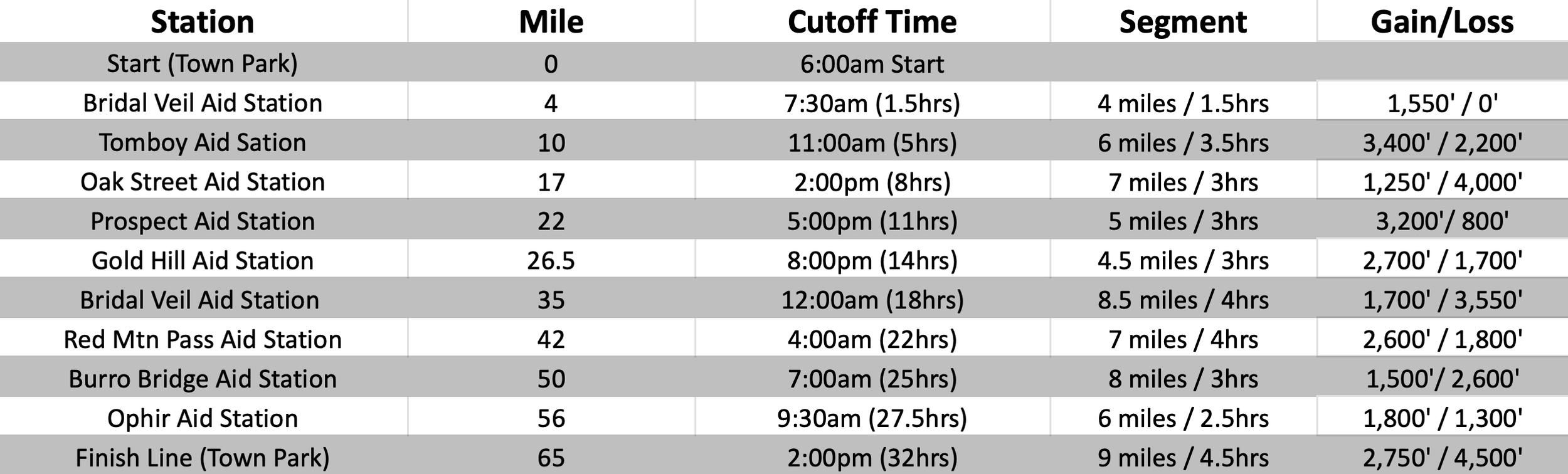
*Cut-off times will be strictly enforced for the safety of the runners. If you check into an aid station after the cut off, you MUST NOT go on.
*Runners must check into and out of each aid station.
*Please inform the nearest aid station captain if dropping out of the race. If not, we will assume you are still out running the course and search and rescue might be out looking for you! You are responsible for finding a ride back to town.
14-Mile

24-Mile

40-Mile
65-Mile
Nutrition
We keep it pretty simple with fruit (oranges, bananas and watermelon) and a variety of salty and sugary items. We'll have chips, pretzels, Goldfish, cookies, fruit snacks, M&Ms, etc. We'll also have a few made up items like PB&J/ Nutella wraps and quesadillas. Aid stations on the back half of the 65-mile run will have a larger variety of hot food including soup/ramen/broth. To drink we'll have water, soda and Tailwind. We don't carry any other energy products and encourage people to bring what they like and will actually eat.
Aid Station Medical
We expect you to be prepared for medical situations unique to your health history. If you have any special conditions (allergies, asthma, etc.) please make us aware when you check in. Be sure to carry any medications or inhalers you might need during the run. We will have people with medical experience on course with basic first aid supplies at aid stations. This event is very remote at times and should be approached with preparation, caution and care. Although we have safety personnel and medical staff available, know that evacuation from any point along the course will be a slow and difficult process. We expect you to be self-sufficient and responsible on race day.
Drop Bags
Please mark all drop bags with your name and bib number and bring them to the starting line on race morning. There will be a designated drop spot for each aid station. Please keep these bags small.
Hill Climb runners will be allow one drop bag for the finish line at the top of Gold Hill. This will need to be dropped off no later than 8:30am at the starting line at Oak Street Plaza.
No drop bags for the 14-mile and 24-mile races.
40-mile runners will be allowed to have two drop bags.
Bridal Veil Aid Station (Mile 11)
Oak Street Aid Station (Mile 24)
65-mile runners will be allowed to have three drop bags.
Oak Street Aid Station (Mile 17)
Bridal Veil Aid Station (Mile 35)
Ophir Aid Station (Mile 56)
CREWING
40-mile runner crewing is allowed at:
Bridal Veil Aid Station (Mile 11)- Hike required
Oak Street Aid Station (Mile 24)- Vehicle parking nearby
65-mile runner crewing is allowed at:
Oak Street Aid Station (Mile 17)- Vehicle parking nearby
Bridal Veil Aid Station (Mile 35)- Hike required
Red Mountain Pass Aid Station (Mile 42)- Vehicle access
Burro Bridge Aid Station (Mile 50)- Vehicle access
Ophir Aid Station (Mile 56)- Hike required
*65-mile- Please read all of the details below regarding driving times, aid station access, and Ophir Pass Road considerations for the back half of the course. It maybe not be possible to crew at both Burro Bridge and Ophir aid stations. Most crews will choose to either support their runner at Burro Bridge and then drive to the finish line in Telluride or drive to the Ophir Aid Station after their runner has left the Red Mountain Aid Station. Remember runners are allowed a drop bag at Ophir Aid Station.
Aid Station Access
We encourage spectators to cheer on the runners along the course and at some of the aid stations. Some stations have vehicle access and others will require hiking.
Hill Climb Finish Line on Gold Hill: Map location here
Vehicle Access: No
Hiking: Take the free Gondola from Telluride (Map location here) to the San Sophia Station (Map location here). This provides easy access to start a hike up the See Forever Trail to the Gold Hill Finish Line (3 miles).
Bridal Veil Aid Station: Map location here
Vehicle access: No. Please DO NOT drive up to this aid station. There is very limited parking and turning a vehicle around on this road can be challenging.
Hiking: Roughly two miles from the Bridal Veil Trailhead.
Parking: Map location here
Tomboy Aid Station:
Please DO NOT drive or hike to the Tomboy Aid Station. This is a high-clearance, 4WD road with a lot of Jeep traffic in the summer and we would like to avoid further congestion on this route.
Oak Street Aid Station: Map location here
Located at the base of the Gondola at the end of S. Oak Street in downtown Telluride.
Prospect Aid Station:
Please no spectating/ crewing at the Prospect Aid Station.
Gold Hill Aid Station: Map location here
Vehicle Access: No
Hiking: Take the free Gondola from Telluride (Map location here) to the San Sophia Station (Map location here). This provides easy access to start a hike up the See Forever Trail to the Gold Hill Aid Station (2.5 miles).
Red Mountain Pass Aid Station: Map location here. The exact location of this station will be in the vicinity of this spot and may change slightly based on conditions.
Vehicle Access: Yes. (1.5 hour drive from Telluride) Please park at the designated parking spots on Hwy 550 at Red Mountain Pass and hike roughly .25 miles up Black Bear Rd to the aid station.
Parking: Map location here
Burro Bridge Aid Station: Map location here
Vehicle Access: Yes. (1 hour 45 minute drive from Telluride) Parking available next to the aid station.
Ophir Aid Station: Map location here. It is important that we are mindful of the residents of Ophir. Please read all of the details below and please park only where is mentioned in this section. The exact location of this station will be in the vicinity of this spot and may change slightly based on conditions.
Vehicle access: Possible.
From Burro Bridge (East): (1.5 hours drive over Ophir Pass) *READ THIS*- Ophir Pass is a narrow, high-clearance, 4WD road with steep drop offs and very few places to back up or turn around. If you do not have a capable vehicle or experience driving on these kinds of technical roads, please do not attempt to drive over Ophir Pass from the Burro Bridge Aid Station… especially in the dark. If you choose to drive Ophir Pass, please note that runners will also be on this road and we encourage drivers to drive very slow to keep the dust down.
From Town of Ophir Direction (West): (2+ hour drive from Burro Bridge Aid Station, 30 minutes from Telluride). If you do not have a high clearance vehicle, please park at the designated parking spot in West Ophir and hike to the aid station (read below). Driving out of East Ophir is a high-clearance road with a lot of Jeep traffic in the summer and we would like to avoid further congestion on this route. There are a handful of parking spots, not many, on the side of the road near the aid station, 1.3 miles up the road. Please do not block the road or any gates.
Hiking (Best Option): Hike roughly two miles through the town of Ophir and up Ophir Pass Rd from the designated parking area in W. Ophir.
Parking: Map location here